![](/images/other/stat-length.png)
![Trail Walking Les Sièges - Hier et aujourd'hui... Promenade aux Sièges - Photo](https://media.geolcdn.com/t/1900/400/ext.pjpeg?maxdim=2&url=https%3A%2F%2Fservices.sitytrail.com%2FGeolivesWS%2FDownloadMedia.ashx%3FTrailID%3D111239%26Media%3D6788_3.jpg)
Hier et aujourd'hui... Promenade aux Sièges
tracegps
User
![Length](/images/other/stat-length.png)
Length
5.9 km
![Max alt](https://static1.geolcdn.com/siteimages/upload/files/1508320355ic_sort_altitude_max_24dp.png)
Max alt
199 m
![Uphill gradient](https://static1.geolcdn.com/siteimages/upload/files/1508320355ic_sort_den_pos_24dp.png)
Uphill gradient
84 m
![Km-Effort](/images/other/stat-length.png)
Km-Effort
7 km
![Min alt](https://static1.geolcdn.com/siteimages/upload/files/1508320355ic_sort_altitude_min_24dp.png)
Min alt
124 m
![Downhill gradient](https://static1.geolcdn.com/siteimages/upload/files/1508320355ic_sort_den_neg_24dp.png)
Downhill gradient
84 m
![Boucle](https://static1.geolcdn.com/siteimages/upload/files/16400158638029165_repeat_loop_refresh_sync_direction_icon.png)
Boucle
Yes
Creation date :
2014-12-10 00:00:00.0
Updated on :
2014-12-10 00:00:00.0
![Walking](https://static1.geolcdn.com/sitytour/trail-icons/101.png)
1h30
Difficulty : Easy
![Scan this QR Code to open this trail in the SityTrail application](https://capi.geolives.com/qq0zvz2zws4bq2lad0pu/sitytour/trails/111239/qr.png?size=200)
FREE GPS app for hiking
About
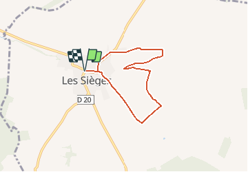
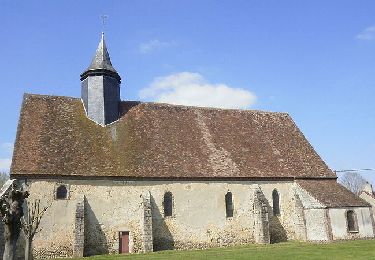
Trail Walking of 5.9 km to be discovered at Bourgogne-Franche-Comté, Yonne, Les Sièges. This trail is proposed by tracegps.
Description
Circuit proposé par le Syndicat d’Initiative de la Vallée de la Vanne et la Communauté de Communes de la Vanne. Départ de la place de l’église de Les Sièges.
Positioning
Country:
France
Region :
Bourgogne-Franche-Comté
Department/Province :
Yonne
Municipality :
Les Sièges
Location:
Unknown
Start:(Dec)
Start:(UTM)
538470 ; 5336543 (31U) N.
Comments
Trails nearby
![Trail Mountain bike Foissy-sur-Vanne - 2018-10-21 Circuit Flacy, Pont sur vanne - Photo](https://media.geolcdn.com/t/375/260/ext.jpg?maxdim=2&url=https%3A%2F%2Fstatic1.geolcdn.com%2Fsiteimages%2Fupload%2Ffiles%2F1524743154velo.jpg)
![Mountain bike Mountain bike](https://static1.geolcdn.com/sitytour/trail-icons/202.png)
2018-10-21 Circuit Flacy, Pont sur vanne
Mountain bike
Very easy
(1)
Foissy-sur-Vanne,
Bourgogne-Franche-Comté,
Yonne,
France
![](/images/other/stat-length.png)
16.3 km | 17.1 km-effort
2h 18min
![](https://static1.geolcdn.com/siteimages/upload/files/16400158638029165_repeat_loop_refresh_sync_direction_icon.png)
Yes
![Trail Walking Les Sièges - 210613 Les Sièges - Photo](https://media.geolcdn.com/t/375/260/64ba87df-9e12-4651-ba1c-320577889f64.jpg&format=jpg&maxdim=2)
![Walking Walking](https://static1.geolcdn.com/sitytour/trail-icons/101.png)
210613 Les Sièges
Walking
Very easy
Les Sièges,
Bourgogne-Franche-Comté,
Yonne,
France
![](/images/other/stat-length.png)
10.8 km | 12.7 km-effort
3h 26min
![](https://static1.geolcdn.com/siteimages/upload/files/16400158638029165_repeat_loop_refresh_sync_direction_icon.png)
Yes
![Trail Walking Les Vallées de la Vanne - De bourg en hameaux - Vareilles - Photo](https://media.geolcdn.com/t/375/260/ext.jpg?maxdim=2&url=https%3A%2F%2Fservices.sitytrail.com%2FGeolivesWS%2FDownloadMedia.ashx%3FTrailID%3D191642%26Media%3D15289_5.jpg)
![Walking Walking](https://static1.geolcdn.com/sitytour/trail-icons/101.png)
De bourg en hameaux - Vareilles
Walking
Medium
Les Vallées de la Vanne,
Bourgogne-Franche-Comté,
Yonne,
France
![](/images/other/stat-length.png)
11.2 km | 14.6 km-effort
2h 45min
![](https://static1.geolcdn.com/siteimages/upload/files/16400158638029165_repeat_loop_refresh_sync_direction_icon.png)
Yes
![Trail Walking Les Vallées de la Vanne - Le bois du Champ-Fêtu - Vareilles - Photo](https://media.geolcdn.com/t/375/260/ext.jpg?maxdim=2&url=https%3A%2F%2Fservices.sitytrail.com%2FGeolivesWS%2FDownloadMedia.ashx%3FTrailID%3D191641%26Media%3D15288_1.jpg)
![Walking Walking](https://static1.geolcdn.com/sitytour/trail-icons/101.png)
Le bois du Champ-Fêtu - Vareilles
Walking
Medium
Les Vallées de la Vanne,
Bourgogne-Franche-Comté,
Yonne,
France
![](/images/other/stat-length.png)
12.8 km | 15.6 km-effort
3h 10min
![](https://static1.geolcdn.com/siteimages/upload/files/16400158638029165_repeat_loop_refresh_sync_direction_icon.png)
Yes
![Trail Walking Les Sièges - La pierre Colon - Les Sièges - Photo](https://media.geolcdn.com/t/375/260/ext.jpg?maxdim=2&url=https%3A%2F%2Fservices.sitytrail.com%2FGeolivesWS%2FDownloadMedia.ashx%3FTrailID%3D191640%26Media%3D15287_5.jpg)
![Walking Walking](https://static1.geolcdn.com/sitytour/trail-icons/101.png)
La pierre Colon - Les Sièges
Walking
Medium
Les Sièges,
Bourgogne-Franche-Comté,
Yonne,
France
![](/images/other/stat-length.png)
8.3 km | 10 km-effort
2h 15min
![](https://static1.geolcdn.com/siteimages/upload/files/16400158638029165_repeat_loop_refresh_sync_direction_icon.png)
Yes
![Trail Walking Les Vallées de la Vanne - Vareilles - Les Thorets - Photo](https://media.geolcdn.com/t/375/260/ext.jpg?maxdim=2&url=https%3A%2F%2Fservices.sitytrail.com%2FGeolivesWS%2FDownloadMedia.ashx%3FTrailID%3D150185%26Media%3D02922737-c5ff-444f-a4d6-41ebc13620e2.jpg)
![Walking Walking](https://static1.geolcdn.com/sitytour/trail-icons/101.png)
Vareilles - Les Thorets
Walking
Medium
Les Vallées de la Vanne,
Bourgogne-Franche-Comté,
Yonne,
France
![](/images/other/stat-length.png)
12.1 km | 15.2 km-effort
3h 30min
![](https://static1.geolcdn.com/siteimages/upload/files/16400158638029165_repeat_loop_refresh_sync_direction_icon.png)
Yes
![Trail Walking Les Vallées de la Vanne - A la découverte de Chigy et la Vallée de la Vanne - Photo](https://media.geolcdn.com/t/375/260/ext.jpg?maxdim=2&url=https%3A%2F%2Fservices.sitytrail.com%2FGeolivesWS%2FDownloadMedia.ashx%3FTrailID%3D111423%26Media%3D7216_4.jpg)
![Walking Walking](https://static1.geolcdn.com/sitytour/trail-icons/101.png)
A la découverte de Chigy et la Vallée de la Vanne
Walking
Medium
Les Vallées de la Vanne,
Bourgogne-Franche-Comté,
Yonne,
France
![](/images/other/stat-length.png)
7.3 km | 8.3 km-effort
1h 49min
![](https://static1.geolcdn.com/siteimages/upload/files/16400158638029165_repeat_loop_refresh_sync_direction_icon.png)
Yes
![Trail Walking Les Vallées de la Vanne - Vareilles - Les Thorets - La Cote d'Enfer - Le Fourneau - Photo](https://media.geolcdn.com/t/375/260/ext.jpg?maxdim=2&url=https%3A%2F%2Fservices.sitytrail.com%2FGeolivesWS%2FDownloadMedia.ashx%3FTrailID%3D151430%26Media%3Db89fd003-5bfc-42b3-807f-5cf5c097e2b4.jpg)
![Walking Walking](https://static1.geolcdn.com/sitytour/trail-icons/101.png)
Vareilles - Les Thorets - La Cote d'Enfer - Le Fourneau
Walking
Medium
Les Vallées de la Vanne,
Bourgogne-Franche-Comté,
Yonne,
France
![](/images/other/stat-length.png)
10.2 km | 13.6 km-effort
3h 0min
![](https://static1.geolcdn.com/siteimages/upload/files/16400158638029165_repeat_loop_refresh_sync_direction_icon.png)
Yes
![Trail Walking Les Vallées de la Vanne - A la découverte d'un hêtre bi-centenaire - Vareilles - Photo](https://media.geolcdn.com/t/375/260/ext.jpg?maxdim=2&url=https%3A%2F%2Fservices.sitytrail.com%2FGeolivesWS%2FDownloadMedia.ashx%3FTrailID%3D111328%26Media%3D7067_2.jpg)
![Walking Walking](https://static1.geolcdn.com/sitytour/trail-icons/101.png)
A la découverte d'un hêtre bi-centenaire - Vareilles
Walking
Easy
Les Vallées de la Vanne,
Bourgogne-Franche-Comté,
Yonne,
France
![](/images/other/stat-length.png)
5.1 km | 6.6 km-effort
1h 15min
![](https://static1.geolcdn.com/siteimages/upload/files/16400158638029165_repeat_loop_refresh_sync_direction_icon.png)
Yes